Felicity,
Thank you for your email since our discussions
at the WRBG working bee this morning at the Amadeus Place gully off Callabonna
Street.
I have done just a quick analysis this evening of the basis for a
walking path design from a junction with the Coucal Trail, Point (A), to the Fig
Tree near Tennent St, Point (B). This analysis and attachments are based
upon on the 1994 aerial photography and terrain data obtained from DNR&M's
new MapView product (recently purchased as part of BCC Environment Grant funded
biodiversity monitoring project).
The
attachments are:
..
Gidgi-Tenn00.jpg Aerial photo image,
showing a straight line from Point (A) to Point (B)
..
Gidgi-Tennent.xls Excel spreadsheet showing
distance and elevation data for the above straight line, which has a length of
less than 400m. The chart in this spreadsheet is not for the alignment of
a walking path. The walking path would deviate from this straight line
longitudinal section to follow closer to the contours.
..
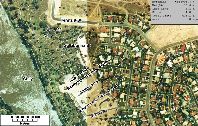
Gidgi-Tenn02.jpg Aerial photo image,
showing a likely route for a walking path from (A) to (B) which would have a
length of about 450m. This route aligns better with the contours for a
graded path, though the last stretch on the approach to the Fig Tree will
require a zig-zag path and/or steps to reach the elevation of the park at
Tennent St.
An outline of the proposal is as
follows:
Purpose
To
provide a walking trail along the Pullen Reach bushland reserve from a junction
with the existing Coucal Trail, northwards across a deep gully opposite Amadeus
Place, and skirting around the contours to connect to the parkland at Tennent
St, nrth-west of the Fig Tree.
Rationale
When the subdivision of Callabonna St from
Amadeus Place to Tennent St was planned and approved, no provision was made for
a pedestrian and cycle connection between Callabonna St and Tennent St at the
boundary of the new residential area and the Pullen Reach riverfront bushland
reserve. A broad, deep gully immediately south of the Fig Tree was filled
for the residential development which was completed in late 1998. Because
no graded pedestrian/cycle was provided, walkers soon created a 'desire line'
path across the two back-to-back allotments which connected Callabonna St and
Tennent St.
SORB representations at the time were
ignored and this faulty subdivision planning was highlighted in an article
SORB's March 1999 Newsletter, viz.: http://www.sorb.org.au/resources/nl11/tennent.htm
This
legacy issue has now come to a head because one of these remaining two (still
vacant) allotments is about to be built upon. This will prevent the many
people who walk along the bushland/residential boundary from Callabonna St to
Tennent St from continuing to walk thi route parallel to the river.
Constraints
The topography of
the broad deep gully south of the Fig Tree, and the lack of provision for a
pathway corridor as part of the subdivision, make it impossible to provide a
direct pathway link between Callabonna St and Tennent St. The roadway for
Callabonna St was built on a fill batter which exacerbated the topographic
challenges for such a link, increasing the elevation above the natural
ground.
In order to provide for continuity of this pedestrian linkage,
with a reasonable grade, the only solution is to construct a new path through
the bushland reserve which follows the contours, below the Callabonna St fill
batter, from near Amadeus Place.
Proposed New Walking Path
Sensible planning
would suggest that a proposed walking path should connect from the existing
Coucal Trail (see http://www.sorb.org.au/maps/Coucal%20Trail.PDF
) nears its northerly limit at Callabonna St near Nisbet St, with the
above-noted alignment west of (and below in elevation to) the Callabonna St fill
batter northwards from Amadeus Close.
The nominal alignment is shown in
green in the attached image Gidgi-Tenn02.jpg.
This proposed path includes
the following elements:
1. Walking Path from Coucal Trail, Point
(A), to a deep gully opposite Amadeus Place - length approx.
150m
2. Bridge structure across this gully - length say 15m,
height approx 4m
3. Walking Path from this gully,
northwards, skirting along the contours to the lower reaches of the gully near
the Fig Tree, then climbing to a point north-west of the Fig Tree
- length approx. 300m.
4. Option of a connecting path
along the north side of gully at Amadeus Place, from Callabonna St to
the above path at the north side of the bridge (2. above) - length approx
50m
The total length of walking path is therefore approx 500m, plus one
major structure opposite Amadeus Place. The climbing grade on the approach
to the Fig Tree end of the path needs to be carefully addressed.
The
standard of construction and surfacing of the Walking Path should be similar
that for the Coucal Trail, with a gravelled surface and edge block treatment, as
built in 1999 under a Green Corps project.
Other Issues
In the past, an informal path had
existed for this full length. The alignment had been constructed as part
of BCC-supervised labour program circa 1994/95 and was kept open by WRBG
volunteers by occasional brush-cutting of Guinea Grass weed infestation.
Since banning of blade brushcutters for WH&S reasons, this work was not
continued by WRBG volunteers and the path has become overgrown and
disused. Guinea Grass remains a challenge for most of the length of the
proposed path.
The alignment of the original path, however, was not
carefully planned and has also suffered land slips. Better planning and
proper design of a new route is essential.
Revegetation of this northern
half of the Pullen Reach site remains a major challenge, and will not occur
naturally nor through volunteer bushcare effort. A major injection of
resources is required to reverse the vegetation damage and ensuing weed
infestation caused by Australand's reckless clearing of the site, several weeks
before the original VPO's came into force in 1991. (That action lead to
the formation of SORB and the subsequent reservation of the land for bushland
park.)
Conclusion
The above proposal provides the
basis for holistic, master-planned approach for a walking path facility and
revegetation in this northern part of the Pullen Reach Bushland
reserve.
We have not been able to cost this proposal, but it would be in
excess of $50,000. (Figures for ecological restoration of vegetation
alone, as quoted at a recent THECA weed management workshop, are $30,000 per
hectare as typical estimate.)
However, if an overall master plan approach
is taken, stage construction would be possible. For example, Items 3 and 4
(path from Amadeus Place to Tennent Street Fig Tree) could be undertaken
first. This first stage would overcome the legacy planning issue of lack
of pedestrian continuity between Callabonna St and Tennent St.